Lower Glenwild ◉
- May 29, 2021
- 2 min read
Updated: Aug 21, 2023
Difficulty: Beginner ◉
Length: 4.8 miles round trip
Elevation Gain: 560 feet
Dog Friendly: Yes
Trailhead coordinates (copy + paste): 40.7280, -111.5364
Directions: Park at the Spring Creek trailhead lot at the coordinates, near the beginning of Glenwild Drive. Follow the obvious trailhead from the lot and continue across the boardwalk, heading West. Around the 0.4 mile mark you will come to a fork—cross the small bridge and continue West, rather than heading uphill to the right. At the next fork 1.3 miles later, take a right onto Stealth Trail. Continue onto the Glenwild trail 0.9 miles after that by taking the path that heads into the trees towards the Park City ridgeline. After crossing the street just below the Glenwild gate house, following the signs toward Spring Creek trailhead (right at the first fork, left at the second) will bring you back to your starting point.
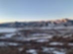
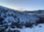
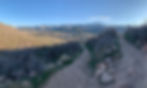
In addition to offering non-stop views of the Park City ridgeline throughout, Lower Glenwild is well-positioned to soak up the last sun of the day, making it perfect for evening hiking. The trail meanders along a South-facing slope for most of its course and has minimal elevation gain, allowing all levels of hikers to enjoy the view along the way. Because of this it can get slushy in the winter afternoons, I recommended this trail for colder days or early mornings before the temperatures start rising each day. The beginning and end of the hike travel along winding East Canyon Creek, and the upper sections look down over the main section of Swaner Preserve. This hike travels almost entirely through Swaner Preserve property, and you will find informational signs along the way with facts about the preserve and local ecosystem.
This trail system is very connected, which makes it easy to shorten or lengthen your hike. The Blackhawk Trail, which starts from a right turn at the aforementioned 0.4 mile mark (head uphill instead of crossing the bridge) is the best way to shave about 2.5 miles off of this hike. When you start, snap a photo of the trail map at the boardwalk to keep for reference. Note: the bottom of the Blackhawk trail (Blackhawk Drop), the part that starts from the 0.4 mile mark, is not pictured on this map. If you have extra time and energy to kill, skip Blackhawk and try following the sign for Cobblestone around the 2 mile mark, which connects to the entire Glenwild loop and brings the total distance to about 8.5 miles.